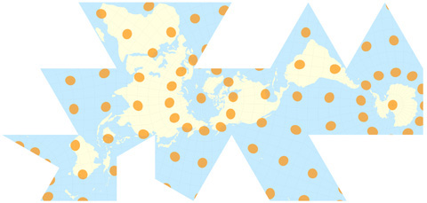
Dymaxion Map
Occupations
This map’s purpose is to present the groups and activities around the world in the OWS family, including not only specific protest organizations, movements and actions but also community-directed enterprises that may manifest as nuclei for new ways of being together and evolving more just ratios of harmonious life. In identifying these sites, the only limit is imagination: Namely we want this plotting of points of possibility to be as inclusive as humanly imaginable.
Place a pin with a flag on an OWS-related site. The flags each have a number—and make sure the number on the flag you want to place follows the last numbered entry in the ledger. Place the pin as close as possible to the site you want to identify (understanding that this Dymaxion Map does not provide place name and boundary location details). Then write down in the ledger:
1. The number of the flag
2. Name of group and/or activity
3. Place of group and/or activity (as applicable its street address, town/city, state & country)
4. Brief description of group and/or activity
5. If possible, a URL link (which may even be a news story) to group and/or activity
6. Anything else that may give substance to your identification
7. Optional: your name and email address (for clarification of entry if necessary)
The hope is that the information gathered through this exhibit will be transferred to a dedicated website, where this Map of Occupations may continue to grow.
Animated projection of a Dymaxion map courtesy Chris Rywalt at Wikipedia
https://upload.wikimedia.org/wikipedia/
commons/b/bb/Dymaxion_2003_animation_small1.gif
The Dymaxion map, developed by Buckminster Fuller in the early 1940s, is a projection of a world map onto the surface of a polyhedron (or “many faced”) two-dimensional surface. This rendering may have several advantages over other map projections. It has less distortion of the relative size and shapes of landmasses and so greater correspondence to reality. It depicts the earth’s continents as “one island,” or nearly contiguous landmass, and so their interconnection. Most tellingly, with the Dymaxion map there is no “right way up” and so becomes a plane on which we may project new ways of imagining Earth. (According to Fuller, the universe has no “up” and “down”, or “north” and “south”—only “in” and “out.” The gravitational forces of the stars and planets, according to Fuller, make an “in” towards and an “out” away from a gravitational center. He attributed the north-up-superior/south-down-inferior presentation of most world maps to cultural bias.)